
Real time update: Remember our blog is usually a few weeks behind our actual location because I upload posts in batches and schedule them to appear one at a time. This post is scheduled to go live on the same day that we'll arrive in Ensenada. Mexico finally!
------------------
How did we decide when to go into Mexico? First, it occurred to us that hurricanes don’t know where the US-Mexico border is and so probably we should think of things…well…probabilistically.
The earlier you go, the more risk. The further South you go, the more risk. Therefore, how much risk are we interested in accepting? What feels safe to us?

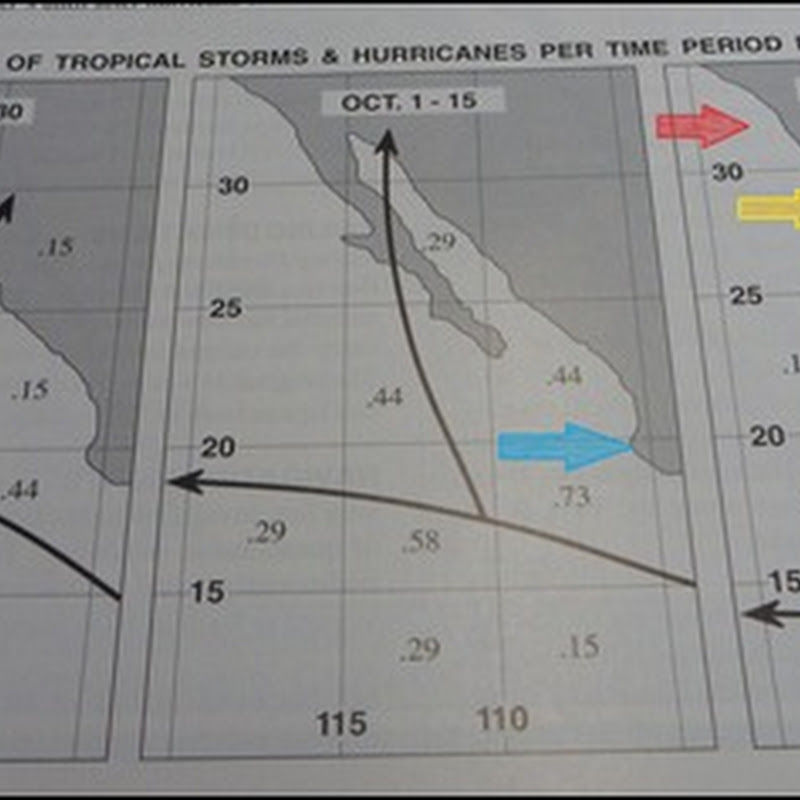
We looked at the incidence rate of hurricanes plus tropical storms in various 5 degree sections of the Baja peninsula*. This picture is based on data that are a bit dated but it still gives the general trend. The three graphs are for various two-week intervals (left to right): end of September, early October, late October.
As I type this, there is a hurricane heading to the coast of Mexico where the blue arrow points in the early October/middle graph. It should surprise no one that has access to hurricane information that there is a hurricane there right now. On average there has been either a hurricane or a tropical storm in that 5 degree square approximately 3 years out of 4.
We decided we wanted to keep approximately one grid between us and historical tropical storm/hurricane risk. 5 degrees of latitude means 300 nautical miles. This is a completely arbitrary cut-off line drawn by us, just like Nov 1, but based on our own risk aversion/acceptance. We are going into Mexico in the late October period (right graph) and we will stay in the grid of the red arrow. By Nov 1 when we will allow ourselves to be in the North half of the grid with the yellow arrow. After that, Southbound again as we wish.
The most conservative thing would be to not enter Mexico until mid-November. Entering at any of those dates does not mean there won’t be any burly storms. There can be burly storms in the Pacific at any time. We keep an eye on the sky (or at least the grib files).
*These graphs are from a guidebook that a friend gave to us as we were passing through California. It is the Baja Boater's Guide: The Pacific Coast


Momma doesn't like headlines about hurricanes from her baby girl.
ReplyDeleteI *do* like to scare you, don't I?
ReplyDelete